 Geodatensuche Berlin
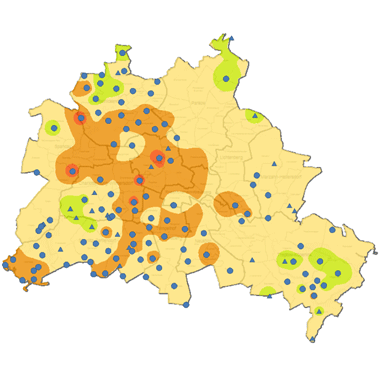
Grundwassertemperatur 2024 (Umweltatlas)
Verteilung der Grundwassertemperatur in 20, 40, 60, 80 und in 100 m unter Geländeoberfläche, durchschnittliche Grundwassertemperatur in 20 - 100 m unter Geländeoberfläche.
Simple
- Date (Creation)
- 2024-11-01
- Date (Publication)
- 2025-08-01
- Identifier
- https://registry.gdi-de.org/id/de.be.csw/a51ee9fa-c229-3cd6-9a79-bf9c2e6d5b78
- Maintenance and update frequency
- Not planned
- Theme
-
-
open data
-
opendata
-
Karten
-
Sachdaten
-
Geodaten
-
Berlin
-
Umweltatlas
-
Geologie
-
Grundwassertemperatur
-
Untergrundtemperatur
-
Neutrale Zone
-
Temperaturjahresgang
-
Temperaturanstieg
-
Temperaturmessstelle
-
IDW-Interpolation
-
Erdwärme
-
-
GEMET - INSPIRE themes, version 1.0
-
-
Geologie
-
- Access constraints
- Other restrictions
- Other constraints
- Es gelten keine Zugriffsbeschränkungen
- Use constraints
- Other restrictions
- Other constraints
-
Für die Nutzung der Daten ist die Datenlizenz Deutschland - Zero - Version 2.0 anzuwenden. Die Lizenz ist über https://www.govdata.de/dl-de/zero-2-0 abrufbar.
- Other constraints
-
{"id":"dl-zero-de/2.0","name":"Datenlizenz Deutschland - Zero - Version 2.0","url":" https://www.govdata.de/dl-de/zero-2-0"}
- Spatial representation type
- Vector
- Denominator
- 50000
- Metadata language
- Deutsch
- Character set
- UTF8
- Topic category
-
- Geoscientific information
))
- Extent type code
- Yes
- Geographic identifier
- 110000000000
- Reference system identifier
- http://www.opengis.net/def/crs/EPSG/0/25833
- Distribution format
-
-
Text/HTML
(
4.01
)
- Specification
-
Keine Angabe
-
Text/HTML
(
4.01
)
- OnLine resource
- Darstellungsdienst - Grundwassertemperatur 2024 (Umweltatlas) (WMS) ( Darstellungsdienst - Grundwassertemperatur 2024 (Umweltatlas) (WMS) )
- OnLine resource
- Downloaddienst - Grundwassertemperatur 2024 (Umweltatlas) (WFS) ( Downloaddienst - Grundwassertemperatur 2024 (Umweltatlas) (WFS) )
- OnLine resource
- Inhaltliche Beschreibung
- OnLine resource
- Technische Beschreibung
- OnLine resource
- Umweltatlas, Karte 02.14
- Description
-
Das Grundwasser-Temperaturfeld von Berlin
- Function
- Information
- Description
-
Veränderung des oberflächennahen Temperaturfeldes in Berlin durch Klimawandel und Urbanisierung
- Function
- Information
- Hierarchy level
- Dataset
- Statement
-
223 Messstellen im Land Berlin aus dem Jahr 2015-2020, Senatsverwaltung für Mobilität, Verkehr, Klimaschutz und Umwelt
- Description
-
223 Messstellen im Land Berlin aus dem Jahr 2015-2020, Senatsverwaltung für Mobilität, Verkehr, Klimaschutz und Umwelt
- File identifier
- f0fd32a2-a503-4ab7-bdf9-73436089a344 XML
- Metadata language
- Deutsch
- Character set
- UTF8
- Hierarchy level
- Dataset
- Date stamp
- 2026-03-23T13:03:47.419123217Z
- Metadata standard name
-
ISO 19115/19119 - BE
- Metadata standard version
-
1.0.0
Overviews
Spatial extent
Provided by
