 Geodatensuche Berlin
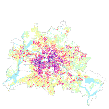
Städtebauliche Dichte - GFZ/GRZ 2019 (Umweltatlas)
Informationen zur real vorhandenen GRZ (Grundflächenzahl) und GFZ (Geschossflächenzahl) als Maß der städtebaulichen Dichte sowie Nutzungsangaben auf Grundlage von 25.352 Block- und Blockteilflächen (ISU5, 2015) sowie zur real vorhandenen GFZ für PLR (Planungsräume, LOR, 01.01.2019).
Simple
- Date (Creation)
- 2016-08-30
- Date (Publication)
- 2017-03-17
- Date (Revision)
- 2019-11-14
- Identifier
- https://registry.gdi-de.org/id/de.be.csw/4a0206a6-c23a-34ee-9947-cfd05ecb6db7
- Maintenance and update frequency
- Not planned
- Theme
-
-
open data
-
opendata
-
Karten
-
Sachdaten
-
Geodaten
-
Berlin
-
Grundflächenzahl
-
Geschossflächenzahl
-
Nutzungsintensität
-
Nutzungsdichte
-
Nutzungsmaß
-
Einwohner
-
Hektar
-
Nebenanlagen
-
bebaute
-
unbebaute
-
Flächen
-
Stadtstrukturtyp
-
differenziert
-
- Access constraints
- Other restrictions
- Other constraints
- Es gelten keine Zugriffsbeschränkungen
- Use constraints
- Other restrictions
- Other constraints
-
Für die Nutzung der Daten ist die Datenlizenz Deutschland - Zero - Version 2.0 anzuwenden. Die Lizenz ist über https://www.govdata.de/dl-de/zero-2-0 abrufbar.
- Other constraints
-
{"id":"dl-zero-de/2.0","name":"Datenlizenz Deutschland - Zero - Version 2.0","url":" https://www.govdata.de/dl-de/zero-2-0"}
- Spatial representation type
- Vector
- Spatial representation type
- Text, table
- Denominator
- 5000
- Metadata language
- Deutsch
- Character set
- UTF8
- Topic category
-
- Planning cadastre
))
- Extent type code
- Yes
- Geographic identifier
- 110000000000
- Reference system identifier
- http://www.opengis.net/def/crs/EPSG/0/25833
- Distribution format
-
-
Text/HTML
(
4.01
)
- Specification
-
Keine Angabe
-
Text/HTML
(
4.01
)
- OnLine resource
- Darstellungsdienst - Städtebauliche Dichte - GFZ/GRZ 2019 (Umweltatlas) (WMS) ( Darstellungsdienst - Städtebauliche Dichte - GFZ/GRZ 2019 (Umweltatlas) (WMS) )
- OnLine resource
- Downloaddienst - Städtebauliche Dichte - GFZ/GRZ 2019 (Umweltatlas) (WFS) ( Downloaddienst - Städtebauliche Dichte - GFZ/GRZ 2019 (Umweltatlas) (WFS) )
- OnLine resource
- Inhaltliche Beschreibung
- OnLine resource
- Technische Beschreibung
- OnLine resource
- Umweltatlas, Karte 06.09
- Hierarchy level
- Dataset
- Statement
-
Blockkarte 1 : 5.000 (ISU 5) des Informationssystems Stadt und Umwelt, Stand 31.12.2015, Amtliches Liegenschaftskatasterinformationssystem (ALKIS), Gebäudeflächen, Stand 13.3.2019, Einwohnerdichte, Stand 31.12.2017 (vgl. Umweltatlas 06.06), Karte der Planungsräume der lebensweltlich orientierten Räume (LOR), Stand 01.01.2019
- Description
-
Blockkarte 1 : 5.000 (ISU 5) des Informationssystems Stadt und Umwelt, Stand 31.12.2015
- Description
-
Amtliches Liegenschaftskatasterinformationssystem (ALKIS), Gebäudeflächen, Stand 13.3.2019
- Description
-
Einwohnerdichte, Stand 31.12.2017 (vgl. Umweltatlas 06.06)
- Description
-
Karte der Planungsräume der lebensweltlich orientierten Räume (LOR), Stand 01.01.2019
- File identifier
- e657a27a-1a5b-32c3-b846-92207b56db40 XML
- Metadata language
- Deutsch
- Character set
- UTF8
- Hierarchy level
- Dataset
- Date stamp
- 2026-01-06T08:42:54.063619174Z
- Metadata standard name
-
ISO 19115/19119 - BE
- Metadata standard version
-
1.0.0
Overviews
Spatial extent
Provided by
