 Geodatensuche Berlin
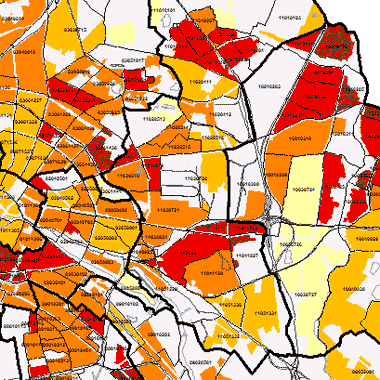
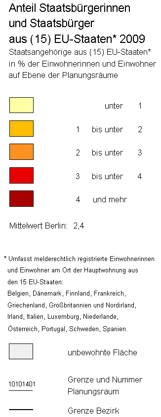
Ausländer 2009 (LOR) - Staatsbürger aus (15) EU-Staaten
Staatsangehörige aus den (15) EU-Staaten in % der Einwohnerinnen und Einwohner auf Ebene der Planungsräume (Monitoring Soziale Stadtentwicklung 2010)
Simple
Identification info
- Date (Creation)
- 2009-12-31
- Identifier
- https://registry.gdi-de.org/id/de.be.csw/07c2a08f-0c6e-3b55-994f-82b78732ef8e
- Presentation form
- Digital map
- Theme
-
-
Karten
-
Geodaten
-
Berlin
-
Monitoring Soziale Stadtentwicklung
-
2010
-
Planungsräume
-
LOR
-
Ausländeranteil
-
Ausländer
-
EU-Staaten
-
MSS 2010
-
- Access constraints
- Other restrictions
- Other constraints
- Es gelten keine Zugriffsbeschränkungen
- Use constraints
- Other restrictions
- Other constraints
-
Für die Nutzung der Daten ist die Datenlizenz Deutschland - Zero - Version 2.0 anzuwenden. Die Lizenz ist über https://www.govdata.de/dl-de/zero-2-0 abrufbar.
- Other constraints
-
{ "id": "dl-zero-de/2.0" , "name": "Datenlizenz Deutschland - Zero - Version 2.0", "url": " https://www.govdata.de/dl-de/zero-2-0" }
- Service Type
- view
- Service Version
-
OGC:WMS 1.0.0
- Service Version
-
OGC:WMS 1.1.0
- Service Version
-
OGC:WMS 1.1.1
- Service Version
-
OGC:WMS 1.3.0
))
- Extent type code
- Yes
- Geographic identifier
- 110000000000
- Coupling Type
- Tight
Contains Operations
- Operation Name
-
GetCapabilities
- Distributed Computing Platforms
- Web services
- Reference system identifier
- http://www.opengis.net/def/crs/EPSG/0/25833
- Distribution format
-
-
Text/HTML
(
4.01
)
-
Text/HTML
(
4.01
)
- OnLine resource
- GetCapabilities Aufruf des WMS mit maschinenlesbarer Antwort
- OnLine resource
- Inhaltliche Beschreibung
- Hierarchy level
- Service
- Other
-
Dienst
- File identifier
- c6d668b4-4625-3c76-8d24-aaf4ee59e659 XML
- Metadata language
- Deutsch
- Character set
- UTF8
- Hierarchy level
- Service
- Hierarchy level name
-
Ausländer 2009 (LOR) - Staatsbürger aus (15) EU-Staaten Dienst
- Date stamp
- 2025-08-08T11:23:58
- Metadata standard name
-
ISO 19115/19119 – BE
- Metadata standard version
-
1.0.0
Overviews
Spatial extent
Provided by
