 Geodatensuche Berlin
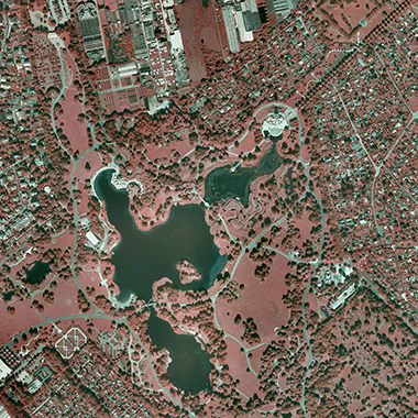
Digitale Orthophotos 2005
Bei den Daten handelt es sich um Digitale Color-Infrarot-Orthophotomosaike (DOP), die aus dem digitalen Bildflug vom 19. bis 31. August 2005 entstanden sind. Die differenziell entzerrten und im Koordinatensystem Soldner erstellten DOPs sind nachträglich nach ETRS89/UTM33 umgerechnet worden. Sie haben eine Bodenauflösung
von 0,20 Meter (20) bei einer Lagegenauigkeit von +/- 20 Zentimeter.
Simple
- Date (Creation)
- 2005-08-31
- Date (Publication)
- 2018-06-22
- Identifier
- https://registry.gdi-de.org/id/de.be.csw/b502c499-9d7e-3826-aeda-31e658215975
- Maintenance and update frequency
- As needed
- Theme
-
-
open data
-
opendata
-
Sachdaten
-
Geodaten
-
Berlin
-
AdVMIS
-
RGB
-
Orthophotomosaike
-
DOP
-
Luftbilder
-
Color-Infrarot
-
Bildflug
-
Topographie
-
Topografie
-
topographisch
-
topografisch
-
- Access constraints
- Other restrictions
- Other constraints
- Es gelten keine Zugriffsbeschränkungen
- Use constraints
- Other restrictions
- Other constraints
-
Für die Nutzung der Daten ist die Datenlizenz Deutschland - Zero - Version 2.0 anzuwenden. Die Lizenz ist über https://www.govdata.de/dl-de/zero-2-0 abrufbar.
- Other constraints
-
{"id":"dl-zero-de/2.0","name":"Datenlizenz Deutschland - Zero - Version 2.0","url":" https://www.govdata.de/dl-de/zero-2-0"}
- Spatial representation type
- Grid
- Distance
- 0.2 metres
- Metadata language
- Deutsch
- Character set
- UTF8
- Topic category
-
- Imagery base maps earth cover
))
- Extent type code
- Yes
- Geographic identifier
- 110000000000
- Reference system identifier
- http://www.opengis.net/def/crs/EPSG/0/25833
- Distribution format
-
-
Text/HTML
(
4.01
)
- Specification
-
Keine Angabe
-
Text/HTML
(
4.01
)
- OnLine resource
- Downloaddienst - Digitale Color-Infrarot-Orthophotos 2005 (DOP20CIR) (ATOM) ( INSPIRE ATOM )
- OnLine resource
- Senatsverwaltung für Stadtentwicklung, Bauen und Wohnen
- Hierarchy level
- Dataset
- Statement
-
Bildflug vom 19. bis 31. August 2005, Bildflug vom 19. bis 31. August
- Description
-
Bildflug vom 19. bis 31. August 2005
- Description
-
Bildflug vom 19. bis 31. August
- File identifier
- bfcbef8b-540c-4227-987b-356f6a7d7792 XML
- Metadata language
- Deutsch
- Character set
- UTF8
- Hierarchy level
- Dataset
- Date stamp
- 2025-11-19T00:00:00Z
- Metadata standard name
-
ISO 19115/19119 - BE
- Metadata standard version
-
1.0.0
Overviews
Spatial extent
Provided by
