 Geodatensuche Berlin
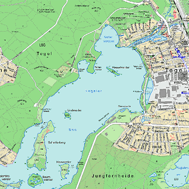
Bezirkskarte Reinickendorf 1:20 000
Topografische Karte des Bezirks Reinickendorf im Maßstab 1:20 000
Simple
- Date (Creation)
- 2013-12-31
- Date (Publication)
- 2022-04-25
- Date (Revision)
- 2021-09-17
- Identifier
- https://registry.gdi-de.org/id/de.be.csw/71d699cb-66d2-3868-9abf-3c9d63b2ddff
- Maintenance and update frequency
- As needed
- Theme
-
-
open data
-
opendata
-
Sachdaten
-
Karten
-
Geodaten
-
Berlin
-
Bezirkskarte Reinickendorf
-
Tegel
-
Konradshöhe
-
Heiligensee
-
Frohnau
-
Hermsdorf
-
Waidmannslust
-
Lübars
-
Wittenau
-
Märkisches Viertel
-
Borsigwalde
-
1:20000
-
Stadtplan
-
- Access constraints
- Other restrictions
- Other constraints
- Es gelten keine Zugriffsbeschränkungen
- Use constraints
- Other restrictions
- Other constraints
-
Für die Nutzung der Daten ist die Datenlizenz Deutschland - Zero - Version 2.0 anzuwenden. Die Lizenz ist über https://www.govdata.de/dl-de/zero-2-0 abrufbar.
- Other constraints
-
{"id":"dl-zero-de/2.0","name":"Datenlizenz Deutschland - Zero - Version 2.0","url":" https://www.govdata.de/dl-de/zero-2-0"}
- Spatial representation type
- Vector
- Denominator
- 20000
- Metadata language
- Deutsch
- Character set
- UTF8
- Topic category
-
- Planning cadastre
))
- Extent type code
- Yes
- Geographic identifier
- 110000000000
- Reference system identifier
- http://www.opengis.net/def/crs/EPSG/0/25833
- Distribution format
-
-
Text/HTML
(
4.01
)
- Specification
-
Keine Angabe
-
Text/HTML
(
4.01
)
- OnLine resource
- Downloaddienst - Bezirkskarte Reinickendorf 1:20 000 (ATOM) ( INSPIRE ATOM )
- OnLine resource
- Darstellungsdienst - Bezirkskarte Reinickendorf 1:20 000 (WMS) ( Darstellungsdienst - Bezirkskarte Reinickendorf 1:20 000 (WMS) )
- OnLine resource
- Karten und Kartenverkauf
- Hierarchy level
- Dataset
- Statement
-
Karte von Berlin 1 : 1 000, ALKIS, K5, Datensätze von Fachämtern
- Description
-
Karte von Berlin 1 : 1 000
- Description
-
ALKIS
- Description
-
K5
- Description
-
Datensätze von Fachämtern
- File identifier
- aa4d8f6c-1972-4409-9471-3247e81a554c XML
- Metadata language
- Deutsch
- Character set
- UTF8
- Hierarchy level
- Dataset
- Date stamp
- 2025-12-15T09:18:13.355810313Z
- Metadata standard name
-
ISO 19115/19119 - BE
- Metadata standard version
-
1.0.0
Overviews
Spatial extent
Provided by
