 Geodatensuche
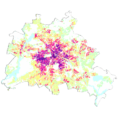
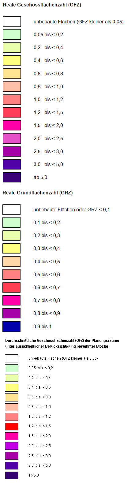
Städtebauliche Dichte - GFZ/GRZ 2019 (Umweltatlas)
Informationen zur real vorhandenen GRZ (Grundflächenzahl) und GFZ (Geschossflächenzahl) als Maß der städtebaulichen Dichte sowie Nutzungsangaben auf Grundlage von 25.352 Block- und Blockteilflächen (ISU5, 2015) sowie zur real vorhandenen GFZ für PLR (Planungsräume).
Simple
Identification info
- Date (Publication)
- 2019-11-14
- Identifier
- https://registry.gdi-de.org/id/de.be.csw/f2613aae-5383-3fd9-a697-e8275d363507
- Presentation form
- Digital map
- Theme
-
-
open data
-
opendata
-
Karten
-
Geodaten
-
Berlin
-
Umweltatlas
-
Nutzungsmaß
-
Nutzungsintensität
-
Nutzungsdichte
-
GFZ
-
Geschossflächenzahl
-
städtebauliche Dichte
-
Flächennutzung
-
Grundflächenzahl
-
GRZ
-
PLR
-
Planungsräume
-
- Access constraints
- Other restrictions
- Other constraints
- Es gelten keine Zugriffsbeschränkungen
- Use constraints
- Other restrictions
- Other constraints
-
Für die Nutzung der Daten ist die Datenlizenz Deutschland - Zero - Version 2.0 anzuwenden. Die Lizenz ist über https://www.govdata.de/dl-de/zero-2-0 abrufbar.
- Other constraints
-
{ "id": "dl-zero-de/2.0" , "name": "Datenlizenz Deutschland - Zero - Version 2.0", "url": " https://www.govdata.de/dl-de/zero-2-0" }
- Service Type
- view
- Service Version
-
OGC:WMS 1.0.0
- Service Version
-
OGC:WMS 1.1.0
- Service Version
-
OGC:WMS 1.1.1
- Service Version
-
OGC:WMS 1.3.0
))
- Extent type code
- Yes
- Geographic identifier
- 110000000000
- Coupling Type
- Tight
Contains Operations
- Operation Name
-
GetCapabilities
- Distributed Computing Platforms
- Web services
- Reference system identifier
- http://www.opengis.net/def/crs/EPSG/0/25833
- Distribution format
-
-
Text/HTML
(
4.01
)
-
Text/HTML
(
4.01
)
- OnLine resource
- GetCapabilities Aufruf des WMS mit maschinenlesbarer Antwort
- OnLine resource
- Inhaltliche Beschreibung
- OnLine resource
- Technische Beschreibung
- Hierarchy level
- Service
- Other
-
Dienst
- File identifier
- 6f83322e-7a6e-3e69-9b14-3649286bbeec XML
- Metadata language
- Deutsch
- Character set
- UTF8
- Hierarchy level
- Service
- Hierarchy level name
-
Städtebauliche Dichte - GFZ/GRZ 2019 (Umweltatlas) Dienst
- Date stamp
- 2025-03-06T12:25:50
- Metadata standard name
-
ISO 19115/19119 – BE
- Metadata standard version
-
1.0.0
Overviews
Spatial extent
Provided by
