 Geodatensuche Berlin
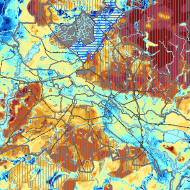
Flurabstand des Grundwassers 2020 (Umweltatlas)
Tiefe des Grundwassers unter der Geländeoberfläche - Flurabstand, in maßstabsabhängiger Genauigkeit, differenziert, Flurabstand bei niedrigen Grundwasserständen
Simple
- Date (Creation)
- 2023-04-15
- Date (Publication)
- 2023-07-05
- Identifier
- https://registry.gdi-de.org/id/de.be.csw/8c737100-9e59-3b94-9ef4-7d1812f08f20
-
GEMET - INSPIRE themes, version 1.0
-
-
Geologie
-
- Theme
-
-
inspireidentifiziert
-
open data
-
opendata
-
Berlin
-
Flurabstand
-
Geologie
-
Grundwasserstand
-
Umweltatlas
-
- Access constraints
- Other restrictions
- Other constraints
- Es gelten keine Zugriffsbeschränkungen
- Use constraints
- Other restrictions
- Other constraints
-
Für die Nutzung der Daten ist die Datenlizenz Deutschland - Zero - Version 2.0 anzuwenden. Die Lizenz ist über https://www.govdata.de/dl-de/zero-2-0 abrufbar.
- Other constraints
-
{ "id": "dl-zero-de/2.0" , "name": "Datenlizenz Deutschland - Zero - Version 2.0", "url": " https://www.govdata.de/dl-de/zero-2-0" }
- Spatial representation type
- Vector
- Spatial representation type
- Grid
- Spatial representation type
- Text, table
- Metadata language
- Deutsch
- Character set
- UTF8
- Topic category
-
- Geoscientific information
))
- Extent type code
- Yes
- Geographic identifier
- 110000000000
- Reference system identifier
- http://www.opengis.net/def/crs/EPSG/0/25833
- Distribution format
-
-
text/html
(
4.01
)
- Specification
-
keine Angabe
-
text/html
(
4.01
)
- OnLine resource
- https://fbinter.stadt-berlin.de/fb?loginkey=alphaDataStart&alphaDataId=wfs_02_07flurab2020@senstadt
- Hierarchy level
- Dataset
Conformance result
- Date (Publication)
- 2010-12-08
- Explanation
-
see referenced specification
- Pass
- No
- Statement
-
- Digitales Geländemodell DGM 1 (SenSBW, III C 1)
- Grundwassergleichen Karte Mai 2020
- Bohrungsdaten des Archivs der Landesgeologie Berlin
- File identifier
- 68a2e251-ec7a-411d-a631-5fd6fa575e1d XML
- Metadata language
- Deutsch
- Character set
- UTF8
- Hierarchy level
- Dataset
- Date stamp
- 2025-08-08T10:16:35
- Metadata standard name
-
ISO 19115/19119 - BE
- Metadata standard version
-
1.0.0
Overviews
Spatial extent
Provided by
