 Geodatensuche Berlin
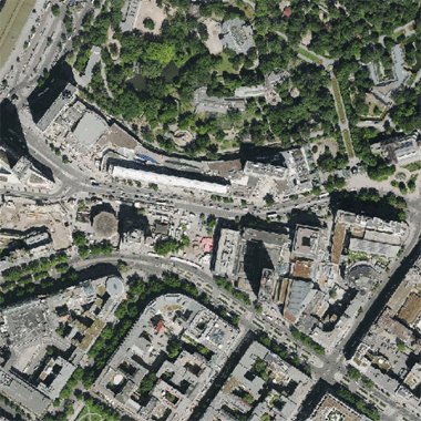
Digitale farbige Trueorthophotos 2018
Bei den Daten handelt es sich um farbige Digitale Trueorthophotomosaike [TDOP], die aus dem digitalen Bildflug August 2018 entstanden sind. Die differenziell entzerrten und im Koordinatensystem ETRS89/UTM33 erstellten TDOP haben eine Bodenauflösung von 0,20 Meter bei einer Lagegenauigkeit von +/- 20 Zentimeter.
Simple
- Date (Creation)
- 2018-08-01
- Identifier
- https://registry.gdi-de.org/id/de.be.csw/cd5b94ab-2335-3d78-a6f4-3b3c44552856
- Theme
-
-
open data
-
opendata
-
Karten
-
Geodaten
-
Berlin
-
Luftbilder
-
DOP
-
TDOP
-
Orthophoto
-
Orthophotomosaik
-
Luftbild
-
Trueorthophoto
-
Trueorthophotomosaik
-
Bildflug
-
Topographie
-
Topografie
-
topographisch
-
topografisch
-
- Access constraints
- Other restrictions
- Other constraints
- Es gelten keine Zugriffsbeschränkungen
- Use constraints
- Other restrictions
- Other constraints
-
Für die Nutzung der Daten ist die Datenlizenz Deutschland - Zero - Version 2.0 anzuwenden. Die Lizenz ist über https://www.govdata.de/dl-de/zero-2-0 abrufbar.
- Other constraints
-
{ "id": "dl-zero-de/2.0" , "name": "Datenlizenz Deutschland - Zero - Version 2.0", "url": " https://www.govdata.de/dl-de/zero-2-0" }
- Spatial representation type
- Grid
- Distance
- 0.2 metres
- Metadata language
- Deutsch
- Character set
- UTF8
- Topic category
-
- Imagery base maps earth cover
))
- Extent type code
- Yes
- Geographic identifier
- 110000000000
- Reference system identifier
- http://www.opengis.net/def/crs/EPSG/0/25833
- Distribution format
-
-
text/html
(
4.01
)
- Specification
-
keine Angabe
-
text/html
(
4.01
)
- Hierarchy level
- Dataset
- Statement
-
Bildflug vom 07.03.2011 und vom 08.03.2011.
- File identifier
- 674b79cb-dc8a-46f1-8db9-7ed0a68c8d19 XML
- Metadata language
- Deutsch
- Character set
- UTF8
- Hierarchy level
- Dataset
- Date stamp
- 2025-08-08T10:16:35
- Metadata standard name
-
ISO 19115/19119 ? BE
- Metadata standard version
-
1.0.0
Overviews
Spatial extent
Provided by
