 Geodatensuche Berlin
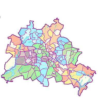
Lebensweltlich orientierte Räume (LOR) (01.01.2019)
Geometrien der Prognoseräume, Bezirksregionen und Planungsräume als Ebenen der lebensweltlich orientierten Räume (LOR), auf die sich die Verwaltungsorganisationen der Bezirksämter ausrichten.
Simple
- Date (Creation)
- 2015-12-31
- Date (Publication)
- 2016-03-02
- Date (Revision)
- 2019-01-01
- Identifier
- https://registry.gdi-de.org/id/de.be.csw/95a3449b-b17e-3db5-b808-171a5ad60da5
- Maintenance and update frequency
- As needed
- Theme
-
-
open data
-
opendata
-
Karten
-
Sachdaten
-
Geodaten
-
Berlin
-
Statistik
-
Verwaltung
-
RBS
-
Planungsraum
-
PLR
-
Prognoseraum
-
PGR
-
Bezirksregion
-
Planungsgrundlagen
-
BZR
-
LOR
-
- Access constraints
- Other restrictions
- Other constraints
- Es gelten keine Zugriffsbeschränkungen
- Use constraints
- Other restrictions
- Other constraints
-
Der Datenbestand wird unter der Lizenz CC-BY-3.0-Namensnennung veröffentlicht (vgl. https://creativecommons.org/licenses/by/3.0/de/). Der Quellenvermerk gemäß Abschnitt 3a der Lizenz lautet "Amt für Statistik Berlin-Brandenburg / Lebensweltlich orientierte Räume (LOR) (01.01.2019)".
- Other constraints
-
{"id":"cc-by-de/3.0","name":"Creative Commons - Namensnennung 3.0 Deutschland","url":" https://creativecommons.org/licenses/by/3.0/de/","quelle":"Amt für Statistik Berlin-Brandenburg / Lebensweltlich orientierte Räume (LOR) (01.01.2019)"}
- Spatial representation type
- Vector
- Denominator
- 5000
- Metadata language
- Deutsch
- Character set
- UTF8
- Topic category
-
- Boundaries
))
- Extent type code
- Yes
- Geographic identifier
- 110000000000
- Reference system identifier
- http://www.opengis.net/def/crs/EPSG/0/25833
- Distribution format
-
-
Text/HTML
(
4.01
)
- Specification
-
Keine Angabe
-
Text/HTML
(
4.01
)
- OnLine resource
- Darstellungsdienst - Lebensweltlich orientierte Räume (LOR) (01.01.2019) (WMS) ( Darstellungsdienst - Lebensweltlich orientierte Räume (LOR) (01.01.2019) (WMS) )
- OnLine resource
- Downloaddienst - Lebensweltlich orientierte Räume (LOR) (01.01.2019) (WFS) ( Downloaddienst - Lebensweltlich orientierte Räume (LOR) (01.01.2019) (WFS) )
- OnLine resource
- Inhaltliche Beschreibung
- OnLine resource
- Darstellung der Daten im Geoportal Berlin
- OnLine resource
- Änderung LOR Allende Viertel ab 01.01.2019
- Description
-
Änderung LOR Allende Viertel ab 01.01.2019
- Function
- Information
- Hierarchy level
- Dataset
- Statement
-
Bereitstellung durch das Amt für Statistik Berlin-Brandenburg
- Description
-
Bereitstellung durch das Amt für Statistik Berlin-Brandenburg
- File identifier
- 5448b07b-31ff-3b67-898c-ea2e1d256b86 XML
- Metadata language
- Deutsch
- Character set
- UTF8
- Hierarchy level
- Dataset
- Date stamp
- 2026-02-12T13:39:16.373876684Z
- Metadata standard name
-
ISO 19115/19119 - BE
- Metadata standard version
-
1.0.0
Overviews
Spatial extent
Provided by
