 Geodatensuche Berlin
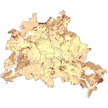
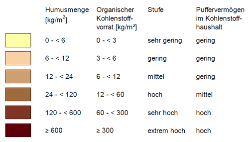
Humusmenge der Böden 2020 (Umweltatlas)
Darstellung der Humusmenge der Böden auf Block- und Blockteilflächen-Basis, 1 : 5.000, Stand 2020.
Simple
Identification info
- Date (Creation)
- 2024-01-13
- Date (Publication)
- 2024-04-30
- Identifier
- https://registry.gdi-de.org/id/de.be.csw/05c1911d-88bd-3099-8b51-16213d772c5a
- Presentation form
- Digital map
- Maintenance and update frequency
- Not planned
- Theme
-
-
inspireidentifiziert
-
open data
-
opendata
-
Karten
-
Sachdaten
-
Geodaten
-
Berlin
-
Boden
-
Umweltatlas
-
Bodendaten
-
Bodenkennwerte
-
Bodenarten
-
nutzbare Feldkapazitäten
-
Flachwurzelzone
-
Flachwurzler
-
Wurzelraum
-
Humusmengen
-
Organischer Kohlenstoffvorrat
-
pH-Wertw
-
Summe austauschbarer basischer Kationen des Oberbodens
-
S-Werte
-
effektive Kationenaustauschkapazitäten
-
KAKeff
-
gesättigte Wasserleitfähigkeiten
-
kf-Werte
-
Substrattypen
-
Bodentypen
-
Bodenformen
-
KA3
-
KA4
-
KA5
-
-
GEMET - INSPIRE themes, version 1.0
-
-
Boden
-
- Keywords
-
-
infoMapAccessService
-
- Access constraints
- Other restrictions
- Other constraints
- Es gelten keine Zugriffsbeschränkungen
- Use constraints
- Other restrictions
- Other constraints
-
Für die Nutzung der Daten ist die Datenlizenz Deutschland - Zero - Version 2.0 anzuwenden. Die Lizenz ist über https://www.govdata.de/dl-de/zero-2-0 abrufbar.
- Other constraints
-
{"id":"dl-zero-de/2.0","name":"Datenlizenz Deutschland - Zero - Version 2.0","url":" https://www.govdata.de/dl-de/zero-2-0"}
- Service Type
- view
- Service Version
-
OGC:WMS 1.0.0
- Service Version
-
OGC:WMS 1.1.0
- Service Version
-
OGC:WMS 1.1.1
- Service Version
-
OGC:WMS 1.3.0
))
- Extent type code
- Yes
- Geographic identifier
- 110000000000
- Coupling Type
- Tight
Contains Operations
- Operation Name
-
GetCapabilities
- Distributed Computing Platforms
- Web services
- Connect Point
- https://gdi.berlin.de/services/wms/ua_boden_humus_2020
- Operates On
- Reference system identifier
- http://www.opengis.net/def/crs/EPSG/0/25833
- Distribution format
-
-
Text/HTML
(
4.01
)
- Specification
-
Keine Angabe
-
Text/HTML
(
4.01
)
- OnLine resource
- Darstellungsdienst - Humusmenge der Böden 2020 (Umweltatlas) (WMS) ( Darstellungsdienst - Humusmenge der Böden 2020 (Umweltatlas) (WMS) )
- OnLine resource
- Darstellung der Karte im Geoportal Berlin
- Hierarchy level
- Service
- Other
-
Dienst
Conformance result
- Date (Publication)
- 2009-10-20
- Explanation
-
see referenced specification
- Pass
- Yes
- File identifier
- 2fe7097e-2809-3e27-8195-0a0903c02491 XML
- Metadata language
- Deutsch
- Character set
- UTF8
- Hierarchy level
- Service
- Hierarchy level name
-
Bodenkundliche Kennwerte 2020 (Umweltatlas) Dienst
- Date stamp
- 2026-01-05T13:02:13.305171865Z
- Metadata standard name
-
ISO 19115/19119 - BE
- Metadata standard version
-
1.0.0
Overviews
Spatial extent
Provided by
