 Geodatensuche Berlin
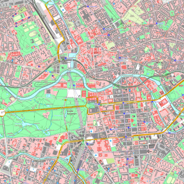
Präsentationsausgabe basemap.de P10 Raster (P10)
Die Präsentationsausgabe basemap.de P10 Raster (P10) ist ein von Bund und Ländern entwickeltes topographisches Kartenwerk im Maßstab 1:10.000. Sie präsentiert deutschlandweit einheitliche und flächendeckende amtliche Geobasisdaten in einer druckoptimierten und maßstabsbezogenen Kartenausgabe. Als inhaltliche Grundlage dienen amtliche Geobasisdaten ATKIS Basis-DLM, Hausrumringe und Digitale Geländemodelle (DGM) der Länder sowie weitere freie Datenquellen (z. B. Zensusdaten).
Die P10 liegt im Geobroker Brandenburg flächendeckend im Blattschnitt der DTK10 auch für Berlin vor.
Simple
Identification info
- Date (Creation)
- 2023-11-18
- Date (Publication)
- 2026-04-24
- Date (Revision)
- 2026-04-24
- Identifier
- https://registry.gdi-de.org/id/de.be.csw/d3f1110a-a62b-3b8f-af05-7677e9dc5e6c
- Presentation form
- Digital map
- Maintenance and update frequency
- Quarterly
- Theme
-
-
open data
-
opendata
-
Sachdaten
-
Karten
-
Geodaten
-
Berlin
-
AdVMIS
-
Rasterkarte
-
Rasterkarten
-
1:10000
-
1:10.000
-
Geobasisdaten
-
Topografie
-
Topographie
-
P10
-
P10 Raster
-
Topografische Karte
-
Topografische Karten
-
Topographische Karte
-
Topographische Karten
-
Rasterdaten
-
Landeskartenwerke
-
topografisch
-
topographisch
-
Amtliches Topographisch-Kartographisches Informationssystem
-
Amtliches Topografisch-Kartographisches Informationssystem
-
ATKIS
-
Präsentationsausgabe 1:10 000
-
Präsentationsausgabe
-
Präsentationsausgaben
-
basemap
-
basemap.de
-
Präsentationsausgabe basemap.de
-
Präsentationsausgabe basemap.de P10
-
Präsentationsausgabe basemap.de P10 Raster
-
Smart Mapping
-
DTK
-
DTK10
-
Digitale Topografische Karte 1:10 000
-
Digitale Topografische Karte
-
Digitale Topographische Karte
-
Digitale Topografische Karten
-
Digitale Topographische Karten
-
- Keywords
-
-
infoMapAccessService
-
- Access constraints
- Other restrictions
- Other constraints
- Es gelten keine Zugriffsbeschränkungen
- Use constraints
- Other restrictions
- Other constraints
-
Für die Nutzung der Daten ist die Datenlizenz Deutschland - Namensnennung - Version 2.0 anzuwenden. Die Lizenz ist über https://www.govdata.de/dl-de/by-2-0 abrufbar. Der Quellenvermerk gemäß (2) der Lizenz lautet "© GeoBasis-DE / BKG (Jahr des letzten Datenbezugs) dl-de/by-2-0 / Präsentationsausgabe basemap.de P10 Raster (P10)".
- Other constraints
-
{"id":"dl-by-de/2.0","name":"Datenlizenz Deutschland - Namensnennung - Version 2.0","url":" https://www.govdata.de/dl-de/by-2-0","quelle":"© GeoBasis-DE / BKG (Jahr des letzten Datenbezugs) dl-de/by-2-0 / Präsentationsausgabe basemap.de P10 Raster (P10)"}
- Service Type
- view
- Service Version
-
OGC:WMS 1.0.0
- Service Version
-
OGC:WMS 1.1.0
- Service Version
-
OGC:WMS 1.1.1
- Service Version
-
OGC:WMS 1.3.0
))
- Extent type code
- Yes
- Geographic identifier
- 110000000000
- Coupling Type
- Tight
Contains Operations
- Operation Name
-
GetCapabilities
- Distributed Computing Platforms
- Web services
- Connect Point
- https://gdi.berlin.de/services/wms/basemap_p10
- Operates On
- Reference system identifier
- http://www.opengis.net/def/crs/EPSG/0/25833
- Distribution format
-
-
Text/HTML
(
4.01
)
- Specification
-
Keine Angabe
-
Text/HTML
(
4.01
)
- OnLine resource
- Darstellungsdienst - Präsentationsausgabe basemap.de P10 Raster (P10) (WMS) ( Darstellungsdienst - Präsentationsausgabe basemap.de P10 Raster (P10) (WMS) )
- OnLine resource
- Darstellung der Karte im Geoportal Berlin
- Hierarchy level
- Service
- Other
-
Dienst
- File identifier
- 54f5c896-3dab-3621-8e4f-8748e7ddfab9 XML
- Metadata language
- Deutsch
- Character set
- UTF8
- Hierarchy level
- Service
- Hierarchy level name
-
Präsentationsausgabe basemap.de P10 Raster (P10) Dienst
- Date stamp
- 2026-05-07T06:17:26.609253067Z
- Metadata standard name
-
ISO 19115/19119 - BE
- Metadata standard version
-
1.0.0
Overviews

Spatial extent
Provided by
