 Geodatensuche
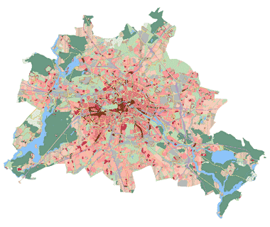
FNP (Flächennutzungsplan Berlin), Stand Neubekanntmachung 2015
Flächennutzungsplan Berlin in der Fassung der Neubekanntmachung vom 5.1.2015 (Abl. S. 31). Es gilt das gedruckte Original in Verbindung mit den separat seit o.g. Neubekanntmachung veröffentlichten wirksamen FNP-Änderungen.
Simple
- Date (Publication)
- 2015-01-16
- Identifier
- https://registry.gdi-de.org/id/de.be.csw/7f8f98b2-eb4c-3ee0-b78e-17a4b93739eb
-
GEMET - INSPIRE themes, version 1.0
-
-
Bodennutzung
-
- Theme
-
-
inspireidentifiziert
-
open data
-
opendata
-
Karten
-
Geodaten
-
Berlin
-
FNP Berlin
-
Flächennutzungsplan
-
Flächennutzungsplanung
-
Vorbereitende Bauleitplanung
-
Bauleitplan
-
- Access constraints
- Other restrictions
- Other constraints
- Es gelten keine Zugriffsbeschränkungen
- Use constraints
- Other restrictions
- Other constraints
-
Für die Nutzung der Daten ist die Datenlizenz Deutschland - Zero - Version 2.0 anzuwenden. Die Lizenz ist über https://www.govdata.de/dl-de/zero-2-0 abrufbar.
- Other constraints
-
{ "id": "dl-zero-de/2.0" , "name": "Datenlizenz Deutschland - Zero - Version 2.0", "url": " https://www.govdata.de/dl-de/zero-2-0" }
- Spatial representation type
- Vector
- Denominator
- 25000
- Metadata language
- Deutsch
- Character set
- UTF8
- Topic category
-
- Planning cadastre
))
- Extent type code
- Yes
- Geographic identifier
- 110000000000
- Begin date
- 2015-01-05
- Reference system identifier
- http://www.opengis.net/def/crs/EPSG/0/25833
- Distribution format
-
-
text/html
(
4.01
)
- Specification
-
keine Angabe
-
text/html
(
4.01
)
- OnLine resource
- Darstellungsdienst - FNP (Flächennutzungsplan Berlin), Stand Neubekanntmachung 2015 (WMS)
- Hierarchy level
- Dataset
Conformance result
- Date (Publication)
- 2010-12-08
- Explanation
-
see referenced specification
- Pass
- No
- Statement
-
Dem Senatsbeschluss Nr. S-1628/2008 beigefügte Karten vom 4.11.08
- File identifier
- 2a2fb313-8fc1-3702-a145-3f8a43831e44 XML
- Metadata language
- Deutsch
- Character set
- UTF8
- Hierarchy level
- Dataset
- Date stamp
- 2025-03-06T12:33:28
- Metadata standard name
-
ISO 19115/19119 ? BE
- Metadata standard version
-
1.0.0
Overviews
Spatial extent
Provided by
